| Bombay Quarry | Bombay | Mix of forest and farm | Map is located on Beaver Road, west of the motorway. Take the northbound exit (from the city it is easiest to go off at Nikau Road and head north to Beaver Road). Also accessible from Jericho Road from Pukekohe. |
| Kueglar farm | Bombay | Mix of forest and farm | Map is located on Beaver Road, west of the motorway. Take the northbound exit (from the city it is easiest to go off at Nikau Road and head north to Beaver Road). Also accessible from Jericho Road from Pukekohe. |
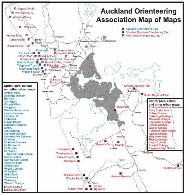
| Kariotahi | Kariotahi | High coastal sanddunes | From the back of Waiuku follor Kariotahi Road towards the coast. Typically signposted from Waiuku township |
| Kawakawa Bay | Kawakawa Bay | Steep gully spur farmland with pockets of native bush and pines | Map is located on the hills east of Kawakawa Bay village. Access is typically off Kawakawa Bay Coast Road or Kawakawa-Orere Road |
| Totara Park | Manurewa | Urban parkland with pockets of native bush | The usual access is from Wairere Road. Alternate access is at the top via Redoubt Road or from Everglade Drive |
| Plantation | Maramarua | Rolling to steep gully spur pine forest | Take SH2 from Maramarua to the Thames turnoff (SH25). U-turn at the roundabout. Entry is the first farm on the left, in front of the pine forest. |
| Reeves Farm | Patumahoe | Extensive farmland | Entry off Ostrich Road south of Glenbrook Road |
| Kohekohe | Kohekohe | High coastal sanddunes with a patch of pines | Typically signposted from Waiuku township. Map is located off Awhitu Road north of Kohekohe. |
| Kelland Road | Pollok | High coastal sanddunes | Typically signposted from Waiuku township. Map is located at the end of Kelland Road. From Waiuku follow Awhitu Road to Waipipi then turn into Kelland Road |
| Huriwai | Port Waikato | Steep limestone country; primarily farmland with small pockets of native bush | Cross the Waikato River at Tuakau Bridge and continue to Port Waikato. Head inland over the hill on Port Waikato-Waikaretu Road. Event centres are typically located near the stock yards in the valley and will be signposted. |
| Sunset View | Port Waikato | Steep limestone country; primarily farmland with small pockets of native bush | Cross the Waikato River at Tuakau Bridge and continue to Port Waikato. Head inland over the hill on Port Waikato-Waikaretu Road. Event centres are typically located near the stock yards in the valley and will be signposted. |
| Ngapuriri | Port Waikato | Steep limestone country; primarily farmland with small pockets of native bush | Cross the Waikato River at Tuakau Bridge and continue to Port Waikato. Head inland over the hill on Port Waikato-Waikaretu Road. Event centres are typically located near the stock yards in the valley and will be signposted. |
| Harkers Reserve | Tuakau | Gully spur farmland with pockets of native bush | Cross the Waikato River at Tuakau Bridge and head uphill on Onewhero-Tuakau Bridge Road. Map is on the west. |
| Waiuku Forest - North | Waiuku | Pine forest on coastal sanddunes | |
| Waiuku Forest - South | Waiuku | Pine forest on coastal sanddunes | |
| Taurangaruru | Waiuku | High coastal sanddunes | |
| Ponganui Road | Onewhero | Steep limestone country; primarily farmland with small pockets of native bush | Cross the Waikato River at Tuakau Bridge and continue to Onewhero. Take Wairamaramr-Onewhero Road and then turn onto Ponganui Road. Event centres typically located near where Ponganui Road turns to Brien Road and will be signposted. |
| Awhitu Regional Park | Awhitu | | |
| Duders Regional Park | Maraetai | | |
| Omana Regional Park | Beachlands | | |
| Auckland Botanic Gardens | Manurewa | | |
| Waharau Regional Park | Clevedon | | |
| Tapapakanga Regional Park | Kawakawa Bay | | |

